Updated: June 30, 2025 at 7:00 AM
If you encounter any downed trees or safety concerns, please call or email the Greenways Dept at (260)427-6228 or This email address is being protected from spambots. You need JavaScript enabled to view it. .
Please be aware, during or following a rainfall, portions of the trail network may be muddy and/or slippery. Please slow down and use caution, especially on boardwalks. Always use caution whenever you encounter a wet section of trail.
During the winter months, be mindful of the potential for ice. In the instance of accumulating snowfall, trails are cleared when 3 or more inches are recorded.
Trail Closures and Detours:
Pufferbelly Trail at Salomon Farm: On Tuesday, July 1st crews will be completing additional crack sealing causing the closure of the trail for 24 hours. This includes the Pufferbelly Trail from Dupont Road to the Parkview YMCA etrance. Please do not disregard the signage that is in place.
Maumee Pathway: Loose Gravel trail segment near Coliseum Boulevard. Please use caution.
Wheelock Road Trail: Crews are installing at new drive way at Jefferson Middle School.
Covington Road Trail: Trail users should use caution near 10332 Covington Road. A section of the asphalt will be removed and replaced with stone.
--------------------------------------------------------------------------------------------------------
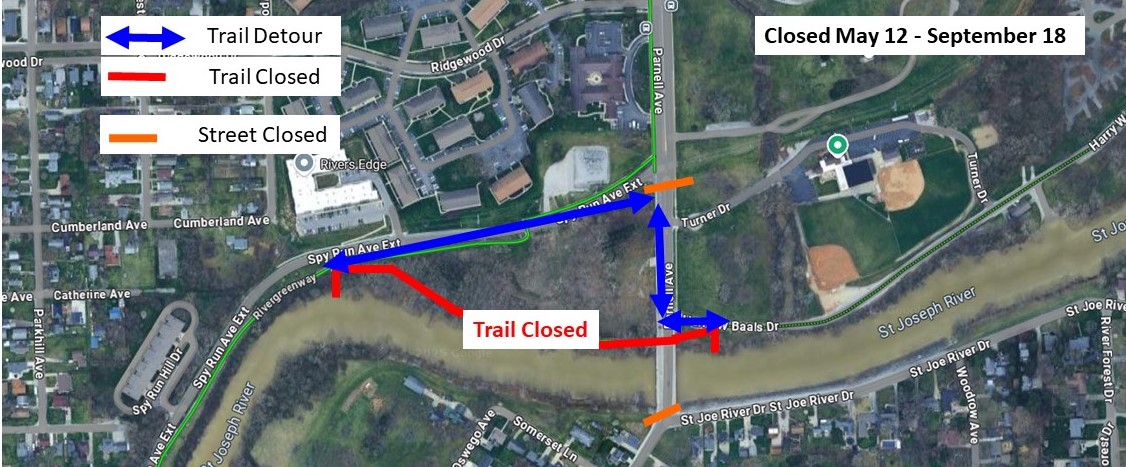
Rivergreenway Detour at Parnell Avenue Bridge: Parnell Avenue will close to vehicle traffic for a bridge rehabilitation project beginning Monday, May 12. Parnell Avenue is expected to remained closed until September 18. Trail users can use Spy Run Avenue Extended and Parnell Avenue as a slight detour during the closure.
--------------------------------------------------------------------------------------------------------
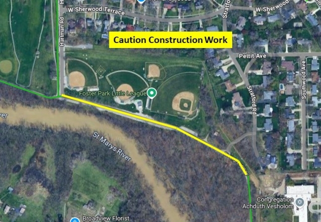
St. Marys Pathway - Please use caution beginning at Hartman Road and continuing south for approximatley 1/4 mile. Construction crews will be working in the area near the trail until the end of June.
--------------------------------------------------------------------------------------------------------
Homestead Road Trail - Please proceed with caution between Jenn Ridge Drive and Liberty Mills Road. City Utilities has made cuts, in two seprate areas, across the entire width of the trail and patched with cold mix.
--------------------------------------------------------------------------------------------------------
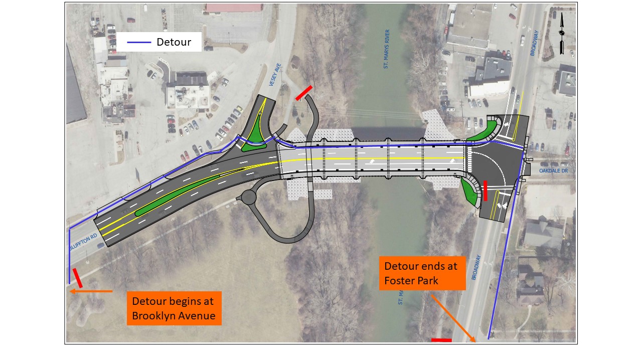
Rivergreenway Detour - The trail will be closed at Brooklyn Avenue with the detour beginning at the crosswalk of Brooklyn and Bluffton Rd. Trail users will use the sidewalk on the north side of Bluffton road to Broadway. At Broadway use the crosswalk to Oakdale and then use another crosswalk to head south on Broadway. Use the sidewalk on the east side of Broadway south to Rudisill. Here you can use the crosswalk to enter Foster Park. Phase 1 is expected to last through August of 2025. Please obey pedestrian signs and signals.
--------------------------------------------------------------------------------------------------------
Landin Road Trail: The trail is closed between Parent Road and Shordon Road for the development of an apartment complex.
---------------------------------------------------------------------------------------------------------
Rivergreenway Closures near Downtown Fort Wayne:
- Riverfront Development (Phase 2) has caused the closure of the St. Marys Pathway between Clinton and Harrison Streets, with a further closure between the Historic Wells Street Bridge and Ewing St. occurring in the near future. This will be in effect through 2025.
---------------------------------------------------------------------------------------------------------
Maplecrest Rd Trail: Construction near Georgetown has disabled pedestrian push buttons at E State Blvd and Maplecrest Rd. Trails users can cross E State Blvd with traffic and are advised to use caution.
---------------------------------------------------------------------------------------------------------
Foster Park Area:
-
A Utilities project has started that affects the trail near Hartman Road. Hartman road has turned into a temporary one-way to allow for pedestrians to use the southbound lane freely.
For specific questions about closures, please e-mail This email address is being protected from spambots. You need JavaScript enabled to view it. or call 427-6228.
Technical challenges have caused the disconnection of this site to present flood gauges. Those interested in seeing current river levels can visit https://water.weather.gov/ahps2/hydrograph.php?wfo=iwx&prob_type=stage&gage=ftwi3